5
Krithika Mukund -
2 years ago
When researching the place, I could not find much info on the walking route or any other details in particular. So would like to share here for anyone else looking for the same.
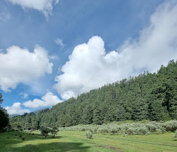
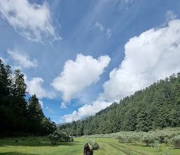
The Cuarto Dinamo is the 4th of the Dinamos, part of a natural reserve of pine forests, hills, a river that forms little cascades as it flows. The fourth dinamo is at the end of the road that goes through this forest and is suited primarily for hiking, there is also ziplining and camping possible.
There is an entry fee of 10 peso per car at the start of the road into the dinamos. This is apart from the 30 pesos charged for parking. One can go all the way till the road culminates at the walk start point, beyond the bridge over the basin formed by the Magdalena river. And there is some parking just before the bridge too where the little streetside restaurants are. ( dont know if the restaurants are open outside of the weekends). If arriving beyond noon, these parking spots are likely to be full and one would need to park much further afore where the buses stop, adding quite a bit of walking on the road to the actual hike. Or along the stony walking path, making turning and taking out the vehicle very difficult later in the day.
The walk up starts right after the bridge over the lake ( river basin) although some choose to go downriver along the cascades and picnic. The uphill walk to the viewpoint had an entry fee on saturday ( adult 10, child 5, bicycle 10, dog 10 mxn) but possibly free ( and more crowded) on Sundays. The path is mostly stone and wide, a few sections uneven and muddy and the final section of 5 minutes rather steep with some loose rocks that one needs to take extra care descending. Not pushchair friendly, good walking shoes recommended and better to avoid at rainy season. Better to wear layers of clothing/jackets.
It is rather high altitude and was 8 deg when it was 16 in the city. But during the uphill hike, one tends to get warmer and would need to shed a layer. The route is easy to follow, wherever there is a doubtful fork in the path, just lookout for signboards that say “ mirador coconetla”. The path, if climbed at a steady pace, takes just under 1.5 hrs for a reasonably fit person and under an hour to descend. It is nearly 4km one way and a 44-storey ascent ( gradual) reaching an altitude of 3360 m at the top. The viewpoint is on the rock mastiff of the mountain one sees from the river basin. The view from the top is over the dense pine forest, the lake below and faraway mountains. There is no particular view as such enroute but the pine forest is beautiful and tranquil enough. Especially on a sunny but cool day in December. I even saw a 2-yr old at the summit and also a lady who seemed to be in her 70s or 80s. The route does not have any seating or any other facilities enroute like toilets or kiosks. Carry own water and make sure not to leave behind any trash. There were toilets before the beginning of the trail (5 peso) but I cannot say whether clean. The food at the little restaurants after the descent , were quite good , enough vegetarian options too and reasonably priced.